KJ6KUV-11 was launched yesterday from Ojai, California at 0820 PDT and successfully recovered 84 minutes later near Oak Park, 53.6 Km to the south-east! Check Kyle's blog for details, but I think all the efforts can be summarized with one single picture:
During the whole flight, the balloon was able to steadily report its position via APRS and the trajectory could be followed at aprs.fi. Between 12-16 Km altitude, the balloon caught the jet stream and sped up quite a lot as you can tell by the more spread-out points on the map!

The tracker was a Trackuino board with a Venus 634FLPx GPS and a Radiometrix HX1 300 mW radio transmitter. We were not sure the HX1 was going to deliver enough power to reach any digipeater from that high up. Well, sure it did... At its peak altitude (20 Km), the signal could be heard from Phoenix, Arizona, which is... 597 Km away!

We were also not sure the Venus 634FLPx would report its position above 18 Km high, since many manufacturers seem to get the CoCom limits all wrong. But then again, the above picture proves how the GPS worked perfectly at 20036 meters.
Here are some flight stats I gathered with WBALTRAK. This is a plot of altitude versus time:

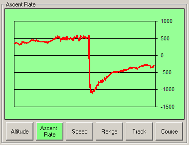
The ascent rate was smooth and constant at about 500 meters/minute. After the balloon popped, the payload fell at a vertiginous 1000 meters/min and steadily slowed down as the air density allowed the parachute to deploy. The payload landed smoothly at 294 meters/min:

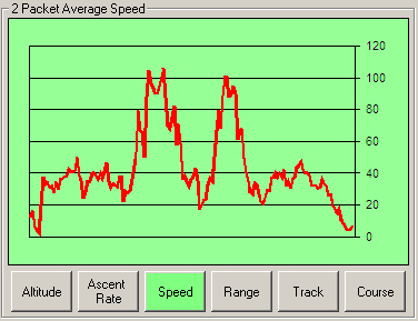
The speed was about 38 Km/h average and it reached peaks of 100 Km/h (about 60 mph) while the balloon was caught by the jet stream:

This was a lot of fun to track :)

